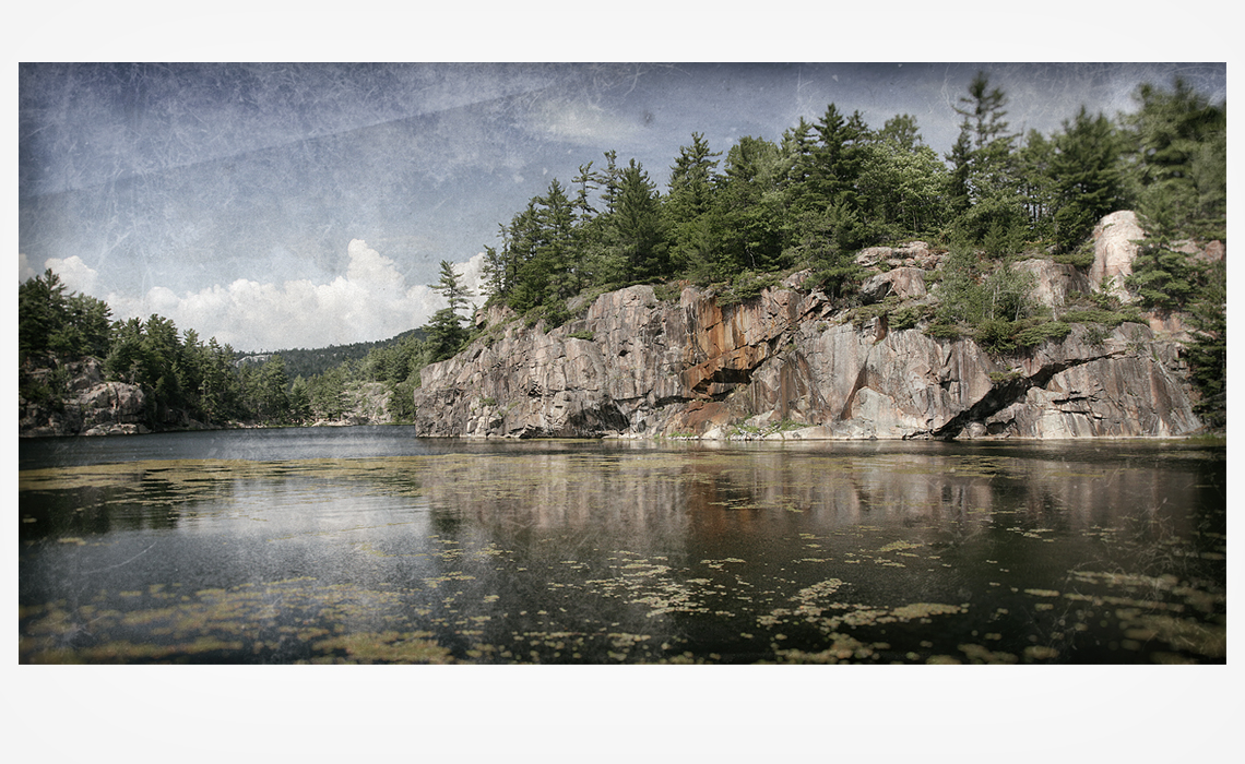
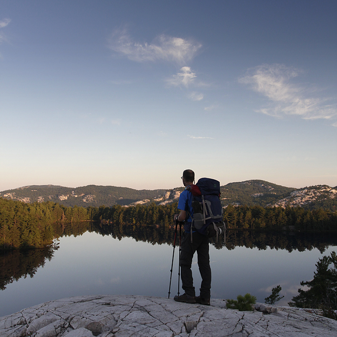
WILDERNESS TRAILS – 10 DAYS ON THE LA CLOCHE SILHOUETTE TRAIL
Where are the canoes? I keep looking for the canoe in the photos because it has been such an integral part of all my trips into Killarney. My first trip into the Killarney backcountry was 1994. Last winter I got inspired to mix it up, try something new. I abandoned the familiar mode of travel to see a different part of the park. I decided to attempt the La Cloche Silhouette Trail and asked a long time canoeing and camping friend (Scott Jordan) to join me. The (80km) trail did share some of the lakes with canoe routes, but many would be new to me. The views from high above the lakes would also be new to me as well as not being in constant proximity to the water.
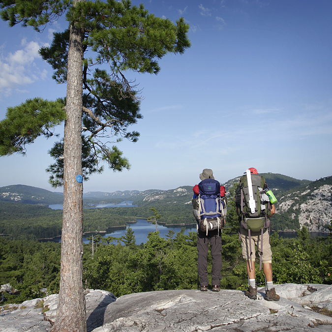
The average time to hike the trail is 5-7 days. We would be spending 10 days on the trail for a couple of reasons: to give us more time during the daily hike to spend filming and photographing and to see and spend time at more of the campsites along the trail.
DAY #1
GEORGE LAKE – TOPAZ LAKE [H7]
11.1 km / 4.25 hr / 31°c
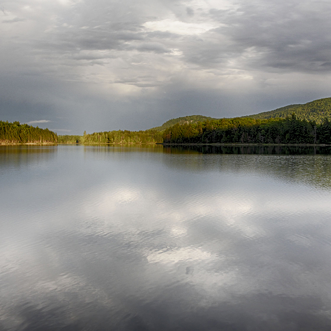
Our first night was spent at Topaz Lake.
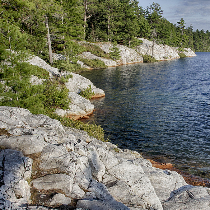
It took us 4.25 hours to get there, passing Lumsden Lake, Acid Lake, Cave Lake, stopping for a break at Artist Creek and then passing by the end of Baie Fine until we finally climbed up to and over the ridge to the entrance of Topaz Lake. We still had to make our way around to the other side of the lake to where the campsite was located. Half way there we both concluded that we had missed a trail marker because the ‘trail’ that we were on was much too narrow and treacherous to be used by hikers with large heavy backpacks. On our way out the next morning we confirmed that we indeed had missed the trail marker. My line of site to where the campsite was lead me to plough straight ahead and made me see a trail that was not there. Because of our late start (2:00PM) and anticipating rain at any time we decided to forgo plans of jumping off the infamous Topaz Lake cliffs and head over to the site to set up, make supper and swim before it got dark. The site was completely under tree cover but very spacious and open underneath. I had plenty of choice for hanging my hammock, however very few level spots to pitch a tent. The water access was isolated to one spot and only a mild slope down to the water’s edge. Swimming was decent – clean & deep – not as nice as the other side of the lake though.
The mosquitos are a non factor by the end of July and on into the season. We did however need to retreat to our tents as the sun set behind the mountains and as we were enjoying our evening campfire. Our fire did not produce enough smoke for us to hide and we had freshened up with a swim in the lake, so we were easy prey for the mosquitos. It was late enough to go to bed, so applying bug spray was not necessary. We were safe from physical harm, but the whiny drone of those tenacious little bugs on the outside of our shelters tormented us for what seemed like hours. It would take a few more nights of this routine before we learned to tune them out.
DAY #2
TOPAZ LAKE [H7] – THREENARROWS LAKE [H19]
15.5 km / 8 hr / 28°c
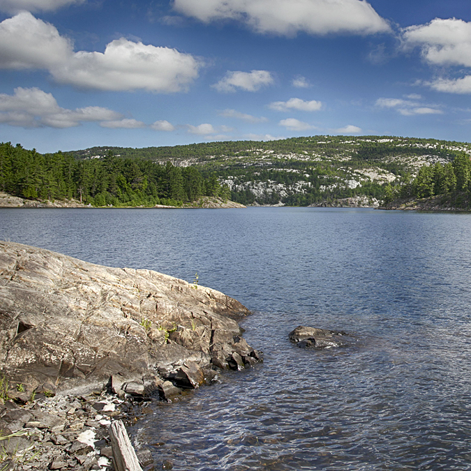
We awoke to an overcast sky that looked like it could go either way – rain at any time or clear up. After making breakfast and packing up our equipment, we started on day two of our adventure, leaving Topaz Lake around 9:30AM. After finishing the ‘Pig’ portage (that we had started the previous day), we headed away from the southern tip of Threenarrows Lake and stopped at the dam where the lake flows over into Kirk Creek. The weather had begun to change and it looked like it would be a beautiful day after all. In mid summer it was dry and very tempting to cross there. Set on completing the trail in it’s entirety, we headed on down the trail as it followed the winding creek until reaching a foot bridge. We crossed Kirk Creek here and followed the trail east, as it eventually reconnected with Threenarrows Lake and then headed northeast until reaching H19. We made stops at both H16 (to eat and refill our water supply) and at H17 for a little victory celebration. It was there, that we had to turn back (in the spring) because of knee problems I was having. My knee pain was behind me now and we were venturing into new territory with each new step. We arrived at H19 around 5:30PM and were amazed at the beauty of a part of the park we had not yet seen before.
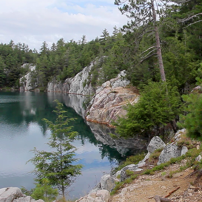
This site is on a flat, open rock outcropping with views to the north facing Doris Island. Water access is easy and abundant. Swimming here is delightful, but with a shallow descent into the deeper water. It was at this site that I first missed our non existent canoe. Looking out across the lake as we sat and ate around the fire, made me instinctively want to hop in the canoe and explore.
DAY #3
THREENARROWS LAKE [H19] – THREENARROWS LAKE [H21]
6.7 km / 3.5 hr / 25°c
We were in no hurry to leave H19. Day 3 was a shorter day, hiking for only 3.5 hours until we reached Threenarrows Lake (H21). This was the first day that we met anyone on the trail – one solo hiker and a couple as well. The solo hiker passed us as we were labouring up a hill and we later met with him again at H20 where we decided to stop for lunch. Nice campsite with a great view over an unnamed lake, but along way down a steep incline to get access to water.
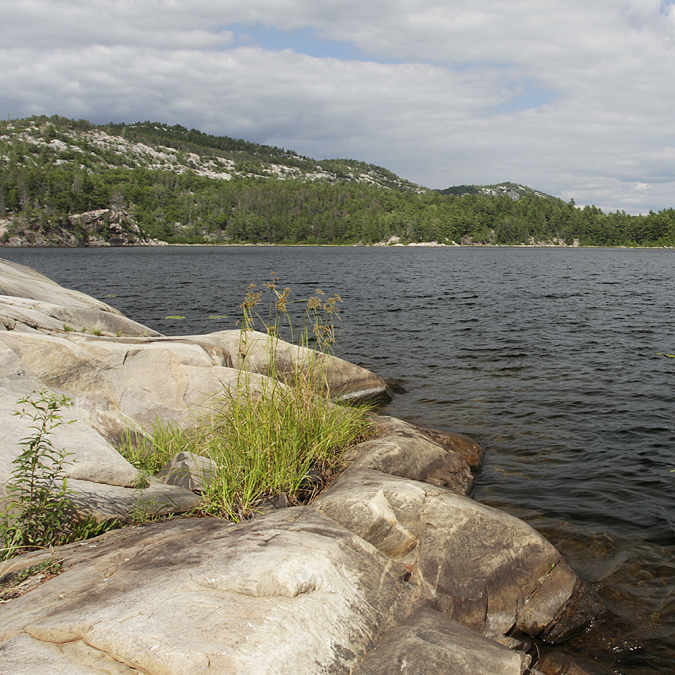
The side trail to H21 was the longest of all the trails to campsites – .75 km. It was well worth the effort! This site was another open rock outcrop jutting eastward into Threenarrows Lake this time facing the west side of Doris Island. It was not as flat as H19, but was more interesting. The swimming was amazing here and water access was every where you could see. After setting up camp, we both had a mid afternoon siesta. The rest of the day was spent relaxing – photographing, exploring and swimming. After our usual routine of supper and a brief camp fire we headed to bed, hopefully recharged and refuelled for the next day – the most physically demanding of our 10 day trip.
DAY #4
THREENARROWS LAKE [H21] – LITTLE MOUNTAIN LAKE [H33]
12.6 km / 9 hr / 23°c
It took us just over 9 hours to make it to Little Mountain Lake. We started our ascent up into the highlands of the Hansen section via a slowly rising valley, crisscrossing the small stream that flowed at it’s base. That eventually lead to us climbing up an almost vertical rock wall, as water rushed over the precipice and down beside us. I knew about the waterfall, but did not expect any water to be flowing over it during one of the driest summers in years. We eventually stopped briefly at an unnamed lake where H22 is, to have lunch and refill our 2L hydration bags. The 2L bags seemed to be the right choice for the distances we were hiking, the availability of lakes and the warm temperatures.
This site is just off the trail, but is nicer than I had anticipated. The water access is very long and steep as it is situated high above the lake. I would not want to swim here, unless I was filthy and needed to get cleaned up. We were not long coming to H23, a steep descent and then the long climb up to Moose Pass where we were eventually rewarded with spectacular views looking south over the Kirk Creek Valley toward, the Blue Ridge of the South La Cloche Range.
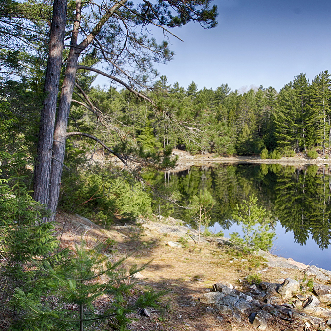
It wasn’t until 5:00PM that we saw, through the trees, the distant shimmer of the turquoise water of Little Mountain Lake.
We still had another hour of the trail descending into the basin that Little Mountain Lake occupies. At times this section was not safe to climb down forwards and was advisable to undo backpack buckles so you could sacrifice the pack and not yourself incase of a fall.
I’m not sure why, but this lake was the coldest of all we swam in. It was also the one we needed the most to clean off a good helping’ of a day’s worth of grime. There is really only one access to swim and get clean water – off to the eastern tip of the site, once you leave the cover of trees which dominates this site. Since we arrived later than usual, there was not much leisure time after our ritualistic swim/clean up in the lake, set up shelters, cook and eat supper and hang our food bags. Our fire, that night, was probably the smallest and shortest of the entire trip. We probably were also too tired to stay up very late after an intense hike like we did that day.
DAY #5
LITTLE MOUNTAIN LAKE [H33] – BOUNDARY LAKE [H35]
6 km / 4 hr / 25°c
The early morning sun penetrated through the wall of trees that lined the shore, obstructing our view of the lake and brightened the previously very dark site that we experienced the previous night. Since the campsite was located at the bottom of a very large hill and facing east, we had not seen direct sun on our site until this morning. After breakfast, as we were packing up, we heard the sounds of canoeists passing through our little lake – on route from Great Mountain Lake on to Threenarrows Lake.
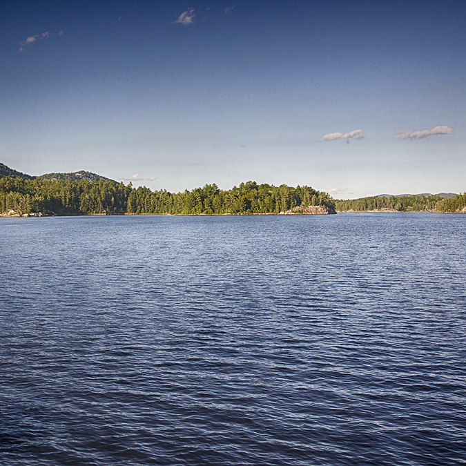
Day five was much easier than the previous day – only 4 hours of hiking and nowhere near the vertical ascents and descents that we had experienced. This section of trail gave of views of Little Mountain Lake and Great Mountain Lake (to the north of us), Silver Peak off in the distance (southeast of us) and a bit later on, David Lake (to the north) and Boundary Lake (to the south).
After another steep and long descent from the ridge, we arrived at H35. It was nice going down, but we were both thinking all along that we would have to go back up this tomorrow morning. Going up first thing in the morning is always easier than if we had to do it at the end of the day.
This campsite has a wooded area at the back and a flat, open area between that and the shore. As soon as we arrived we set up our shelters and I went for a swim. Our site on Boundary Lake was on a canoe route with only one campsite for canoeists and one site for hikers. While eating dinner we heard the sounds of distant conversation and paddles drumming on gunwales as a lone canoe paddled by to reach their site. Late afternoon, the sky clouded over and begin to lightly rain – not enough to send us packing and hiding in our tents. As I continued to photograph the sky started to clear up and the early evening sun shone through a break in the clouds and illuminated isolated areas of the landscape. This lasted only minutes during which I frantically photographed the scene before the light disappeared.
DAY #6
BOUNDARY LAKE [H35] – SILVER LAKE [H37]
6.8 km / 3 hr / 30°c
It took us 3 hours to get from Boundary Lake to our next site on Silver Lake. Most of this trail was already familiar to both of us because it is the trail that also leads canoeists from the David Lake to Boundary Lake portage up to Silver Peak. Most of the trail is relatively flat or downhill until you get to the junction where you decide to stay on the L.S.T. or go up to Silver Peak. Going up to Silver Peak really means going up – it is quite a steep climb the rest of the way up to the highest point in the park. We continued to follow our blue trail markers that led us down the most wide, flat and smooth section of the entire trail, until we then headed south and back up to the top of the ridges again.
It wasn’t long until we were at Silver Lake, setting up camp and trying to decide if we were going to swim. Neither of us like to swim if the lake is full of plant life. Our water access had one small area (not deep enough to dive and too deep to walk into) in which to propel ourselves, rather awkwardly, out past the marshy area into the deeper and clearer water to swim. We both exited the lake about as fast as it took us to get in – just enough time to clean ourselves off! While entertaining ourselves for the afternoon around camp, we realized just how close H38 was to us. If we listened closely enough, we could have joined into our neighbours conversation. I started having car camping flashbacks of listening reluctantly to neighbouring conversations until the wee hours of the morning while desperately trying to sleep. In the end, it was not our H38 neighbours that kept us up – it was a combination of the heat and the frogs that night!
DAY #7
SILVER LAKE [H37] – BUNNYRABBIT LAKE [H45]
5.1 km / 3.25 hr / 29°c
Bunnyrabbit Lake, from the map, does indeed look like a rabbit, but not so much from the shore of the lake. From the shore of this lake all you see is this vividly clear blue water drawing you into its refreshing depths. It is a bit of a steep descent down to the waters edge, but has an intimate rocky area in which to enjoy the lake from. It was a beautiful warm summer afternoon with nothing to do except enjoy where we were, reflect on the journey that had brought us here to this point and to anticipate the trail ahead of us. Three guys, who left the main trail to refill their water supply, stopped by our campsite and we chatted for a good half hour or so. We did not have much contact with others on the trail. It was always a pleasure to talk with fellow hikers and share in the experience of hiking the La Cloche Silhouette Trail.
While hiking the trail there are three predominant things that occupy our conversation. The first is the obvious practical details of the trip – hows your water supply, I need a break when we reach the top, did we miss the trail marker and so on. The second is conversation about how incredibly beautiful this place is and lets stop to film here or which campsite do you like best so far. The third topic of conversation that occurs many times a day starts with what are we having for dinner tonight, quickly followed with talk about what things we would love to be eating that we cannot have right now. The conversation seems, at first, a bit masochistic but remarkably feels more so like a celebration of food and all things culinary. We have years of dehydrated meal preparation between us both and we enjoyed some good food. Meals like pull pork wraps, chili, sausage with pasta & peppers, Indian chick pea curry & rice were a good reason to get excited about what we were having for dinner, especially after hours of backpacking every day. So, I believe we enjoyed a chicken & herb pasta dish that night, while sitting around a campfire delighting in our surroundings and all that we had experienced so far.
DAY #8
BUNNYRABBIT LAKE [H45] – LITTLE SUPERIOR LAKE [H49]
6.5 km / 4 hr / 31°c
During the night we received a light rain, only enough to dampen everything.
We did have to scramble in the early hours of the morning to retrieve our clothes that had been drying on the line. By the time we awoke, the sun was already out and starting to dry the rain on our shelters.
We set off around 10:30AM (our latest departure time) and it wasn’t long before we started to witness the many beautiful mountain lakes in the Killarney Ridge section of the trail. First was Whiskeyjack Lake and then a brief stop on the shore of Heaven Lake. After a small downhill section, the trail joined (temporarily) with the Kakakise Lake to Norway Lake portage. Then it was back uphill again until we eventually were standing high above, looking out over Shingwak Lake, one of the highest lakes (386m.) in the park. Proulx Lake is not visible from the trail and neither is Little Superior Lake if you are hiking the trail clockwise.
Somewhere on the trail, between Bunnyrabbit Lake and the portage from Kakakise Lake to Norway Lake, we crossed paths with 4 young guys. While chatting with them I noticed the amount of gear they had and especially how much of it was dangling on the outside of their packs.
They told us they had camped on the portage trail the night before because it was too dark to reach their intended site for the night. We wished them a good trip and continued on our way. About 5 minutes later, one of them was running down the trail after us, yelling “Have you seen our map?” When he had caught up with us, he explained that he could not find their map. While deciding on a course of action with him, I noticed the duct tape and gauze bandage haphazardly wrapped around his knee, with a bit of dried blood on his shin. I dared ask what happened and was told that his machete slipped while chopping wood and got his knee. After a bit more searching, we suggested he photograph our map with his mobile phone and continued on our way, all the while imagining what further adventures these boys were going to have.
Our first glimpse of Little Superior Lake was that from our campsite. The site was situated on the eastern shore of the lake.
We spent another afternoon of photographing, swimming and relaxation on one of the best campsites of the trip.
The water here was some of the most intense blue we had witnessed and the white quartzite shoreline was a beautiful contrast with the water. We knew that we had an early start planned for the next day, so we got the business of supper and fire started earlier than usual, hoping that sleep would not evade us as we retired earlier than usual.
DAY #9
LITTLE SUPERIOR LAKE [H49] – LITTLE SHEGUIANDAH LAKE [H53]
12.5 km / 7 hr / 32°c
On day 9 of our trip we were on the home stretch, headed to Little Sheguiandah Lake. The 5:30AM wake up was by far the earliest of the trip, but was necessary to get early morning light when we reached the crack. Packing up and making breakfast by the light of our headlamps was a first for the trip.
We experienced dawn’s first light as we made our first climb of the day and were treated to a spectacular view (to the north of us) of Little Superior Lake. We reached the Crack around 8:30AM and enjoyed the panoramic view of Killarney and O.S.A. Lakes, nestled between the Blue Ridge and the Killarney Ridge of the South La Cloche Range. During the summer months the Crack is crawling with hikers – unless you get there early or arrive late enough to avoid the crowds. We witnessed only two people during our 45 minute break and they were fellow L.S.T. hikers. It is easy to see why many hikers make this spot a destination, where for us it was another place to enjoy the view along the way to the end of the trail. After descending from the Crack, the trail became relatively flat as we passed by Kidney Lake, Kakakise Lake, Sealey’s Lake, Freeland Lake and Wagon Road Lake before we arrived at Little Shegiandah Lake.
We stopped at Sealey’s Lake to eat lunch and realized I had just run out of water. I was not excited about filtering water to drink out of this lake. It is not the type of lake you would want to swim in, let alone drink out of. I scooped up as much water as I could with the dirty bag of the Platypus Gravity Works filter and tried not to include and plant life or small fish. The filter did its job – I did not get sick from drinking Sealy’s Lake water. The rest of the days hike was fairly flat and we could move at a good pace – something we had not been accustomed to since the small section of trail that took canoeists from the David Lake/Clearsilver Lake portage to Silver Peak, back on day six. We arrived at Little Sheguiandah Lake around 1:30PM because of our early start. That left us plenty of time to enjoy the site (exploring, swimming, camp fire, reading, our last supper).
DAY #10
LITTLE SHEGUIANDAH LAKE [H53] – GEORGE LAKE
2.8 km / .75 hr / 33°c
This was a bittersweet moment of our trip. Waking up and knowing we would not be hiking to another campsite on one of Killarney’s beautiful mountain lakes, but would be instead hiking to our vehicle and then driving back home. We both were excited to go home (especially to reconnect with our families) but were also sad that we could see the end of our adventure together. The weather seemed to reflect our current mental state of mind as well. It started to rain and stopped, started to clear but didn’t. We poked around the campsite and surrounding area for awhile, maybe hoping that the rain would clear or maybe delaying the inevitable. For the first time of the trip we had to pack up our tents wet. The rain did not last very long and when it did clear, the humidity came out with the sun. Thankfully the hottest day was also our shortest day.
The first item on the ‘let’s go home list’ was a shower and a change off clothes for the drive home. A hot shower at the campground facilities combined with the sudden increase in temperature and humidity made the A/C in the truck an ‘oasis of cool’ that we had been dreaming about for ten hot and sweaty days!. The second item on that list was a lunch in the village of Killarney – beer, burger and fries, but not before we made a stop at Killarney Outfitters to return a few pieces of equipment they had loaned us for the trip.
There were many times throughout this 10 day hike that I wished I had a canoe, to further explore these new lakes I had never seen before. Since we spread out the trail over 10 days, I believe we had a handful of shorter hiking days (that most L.S.T. hikers don’t have) and so the extra time (on site) in the late afternoon, especially gave way to thoughts of “If I had a canoe I could paddle over to the rock face across the lake” or “It’s kind of swampy here, let’s find a better spot to swim”.
I am also very used to the freedom of photographing anything I can see across the lake, because I have quick access to it by canoe. It is also much easier to carry your gear in the canoe instead of on your back. I know that some of the portages are long and hilly, but the majority of travel is done on a flat body of water with no change in elevation.
However, there is something intoxicating about life on the trail that I had never experienced before. On canoe trips, I have enjoyed the sense of solitude of being out on these lakes with very few people around. On the trail, that sense of solitude is more intense. Because of our mode of travel and the location of the trail, we are even more removed from civilization. Travelling through the valleys, up and over steep hills, crossing many creeks and walking along treeless mountain ridges we found ourselves moving days away from any quick exit from the park. As we looked at the map, we saw where we had been the previous day, where we were, where we still needed to go and realized just how far we had travelled – by the power of our own 2 feet with all our daily necessities on our back. The simple act of walking, I also found quite therapeutic. There is a wonderful rhythm to it, similar to paddling, but strangely different. I still love canoeing, but have found a new love, a new way of enjoying the backcountry.